Early History
Every old place begins long before its own records begin, and Hall Place is no exception. The land here was shaped first by water and sand, then by the movements of animals and the people who followed them, and only much later by manors, parks and houses. The earliest chapters of this story cannot be read from documents, because none exist; they have to be read from the ground.
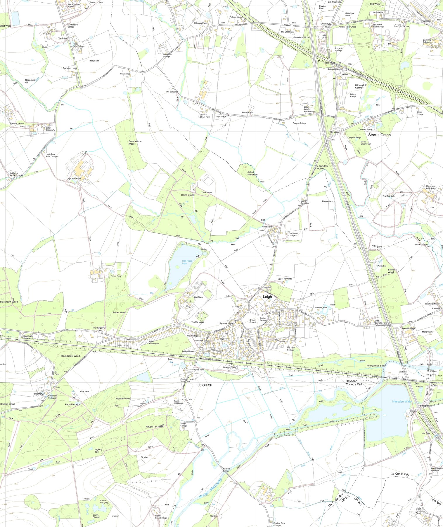
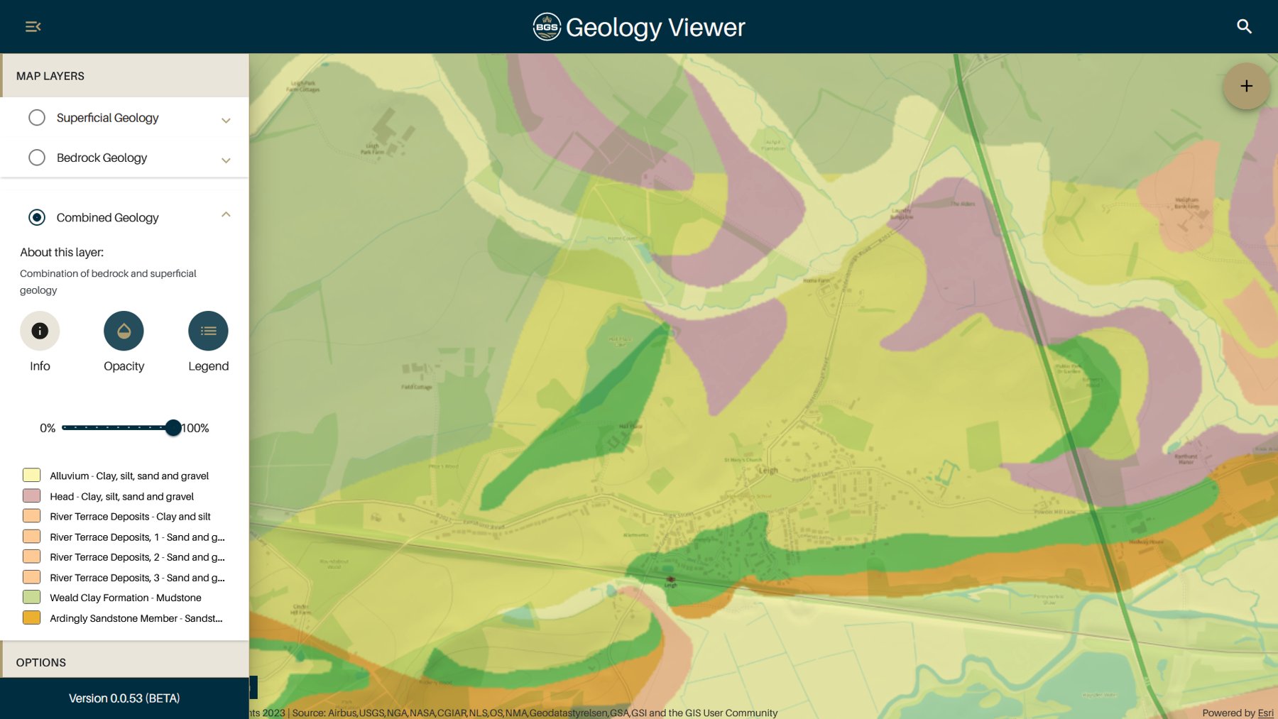
The ground itself sets the scene. Hall Place stands where two very different Wealden landscapes meet: the confined, wooded country of the High Weald and the heavier, damper clays of the Low Weald. The edge of the High Weald Area of Outstanding Natural Beauty still follows the park’s southern boundary, and the estate sits at the junction of the two national character areas, a meeting of landscapes that has governed the way this land has been used for as long as anyone can tell. The site itself lies on the Upper Tunbridge Wells Sand, a rock that gives poorly-drained acidic soils — unpromising ground for the plough, but congenial to trees, grazing and water. Weald Clay, heavy and acidic, runs down the western edge of the park; along the eastern side the sand is partly overlaid by Grinstead Clay; further northeast lie deposits of Head. Water is never far away here. Seepage lines cross the site, and a spring rises within it — the same spring, in all likelihood, that later supplied the moated enclosure generally taken to be the location of the first house at Hall Place. The lake that now fills the central valley is fed chiefly from the southwest, and beyond the park, low-lying land threaded with streams drains away northwards towards Hildenborough. All of this water, like the land, belongs to the wider catchment of the River Medway.
It was water, trees and pasture that made this country attractive to the earliest people we can detect. Across the Weald of Kent as a whole, there is evidence of human activity from the Mesolithic period onwards — the age of the hunter-gatherers, more than five thousand years before the present park was enclosed. For Hall Place itself the record is almost silent. No settlement, no field system, no ritual site has been found here from those early ages. What there is, is a single, evocative accident: the chance find of an Iron Age gold coin somewhere in the locality, recorded in the Historic Environment Register. One coin proves very little on its own. It does not mark a settlement or a hoard in any secure sense. But it is a reminder that people passed this way, and that the Iron Age communities of the Weald — the people who gave the district its ancient fabric of woodland, pasture and trackways — knew this ground.
If direct evidence is thin, the wider pattern of early Kentish settlement offers a better guide to what Hall Place’s landscape was for. A distinctive feature of the Weald was the system of seasonal pastures known as dens. From the established farmlands of northern Kent, stock were driven each summer out to the Weald’s rich seasonal pastures, and each distant pasture was a den — an outlying grazing attachment of a settlement far away. The seasonal movement of grazing and foraging animals from the good lands of north Kent out to these Weald pastures may well have its origins in prehistory, though the earliest certain evidence for the practice is late medieval. Either way, the pattern explains the shape of the parish. Much of the land that became the parish of Leigh consisted of precisely such dens, belonging to settlements in the Darenth Valley some thirty kilometres to the north.
Two groups of these northern claims matter for Hall Place. The first was Penshurst, which was the focus of dens attached to the great estate of the Archbishop of Canterbury at Otford. The manor that formed at Penshurst itself held outliers in Leigh, and it was from this penumbra of Penshurst lands that the landscape immediately around Hall Place was first organised. The second was the estate at Kemsing, whose outliers formed the later manor of Leigh Hollanden, with lands to the east of Hall Place. These two descents — a Penshurst strand and a Kemsing strand — run like double threads through the later medieval history of the parish, and both of them end up, in time, woven into the Hall Place estate.
The church adds its own hint of great antiquity. St Mary’s stands prominently, close beside a river crossing, and it has been suggested that so prominent a site near a crossing point was chosen because a drove route — one of those seasonal stock roads between the northern farms and the Weald pastures — passed that way. If so, the church, the village and the park all grew up around a line of movement far older than any of them: a road worn by the feet of animals long before it was worn by carts. Today the old drove would have passed along the very edge of the park, between the churchyard and the East Park gate, a ghost of an ancient route that still shapes the way the land is divided.
What of the parkland itself? The country around Hall Place has been dominated by parks for centuries: Penshurst Place Park lies to the south, with its former satellite parks of Lye and Northlands gathered around Hall Place; Hildenborough Park stood a short distance away, as did the later park at Redleaf; and away north on the Greensand ridge stand grander places still, such as Knole. Hall Place is one thread in that wider weave. Whether the park here was first enclosed in the medieval period or later, the setting — rising ground at the meeting of two Wealden landscapes, watered by a spring, skirted by ancient woodland — is exactly the sort of ground that successive generations chose for a house, a garden and a deer park. Price’s Wood, on the park’s western side, is identified as probable ancient semi-natural woodland: a fragment of the primaeval Wealden cover that survived every change of ownership.
Where does this early story end? It ends, conventionally, with the Norman conquest — though for this corner of Kent the conquest’s great survey, Domesday Book, is itself a kind of silence. Penshurst does not appear as a manor in Domesday Book at all; the estate whose outliers shaped this parish had not yet emerged in the form the later records know. Out of that post-conquest obscurity the manors of Penshurst and Leigh Hollanden would take shape over the following centuries, and one of their outliers would become, by the early Tudor period, a moated house in a paled park called Hall Place. That later story belongs to other pages. What the earliest era leaves the estate is more fundamental: the ground, the water, the woods, the old drove road by the church, and a habit of seasonal movement reaching back beyond memory. The park we know is simply the latest way of using a landscape that people have been using, in one way or another, since the first hunters followed the game into the Weald.
This page draws on the estate’s Conservation Management Plan (2023) and the National Heritage List entries for Hall Place and its registered park.